GEOMATICS
USD $150 per hour
Our Geomatics service caters to the needs of those who are looking for additional map-making assistance that may or may not be related to our UAV mapping services. We have vast experience in this field and can produce any type of output or offer any support that you may need. For example, let’s say you already have a Digital Elevation Model that you would like to generate custom maps from, or perhaps you’ve been given LiDAR data and you are unsure how to process it, or possibly you need help converting maps and data to different formats or projections, or maybe you know you need certain maps but you don’t know how to proceed. Whatever the case may be, we are here to assist you and are able to accommodate your personal needs and preferences.
PROCESS
- Contact
Contact us about your project and we will write back to confirm we can take it on. - Data
Depending on your needs we may request that you provide us with some data. For example, a property boundary in .kmz or other geospatial data. - Processing
We will then process your project and create all of the outputs you request. - Feedback
We will send you the outputs for preview and ask for feedback. - Payment
We will perform any iterations necessary, based on your feedback, and finalize the outputs. You can then pay the entirety of the fee for the service through this web page. - Delivery
We will send the outputs via Google Drive and/or email.
STANDARD
USD $80 per flight (< 3000 images)
Our most popular photogrammetry service for members of the Regrarians Workplace. You do the flying, we do the flight planning, photo processing, and mapping output.
PROCESS
- Contact & Boundary
Contact us about your project and send us in a .kmz file the boundary of the area subject to mapping. We will then write back to confirm we can take on your project. - Payment
You then pay the entirety of the fee for the service through this web page. - Flight Plan
We will then create an optimal and safe flight plan and send it to you. - Fly
You then fly the UAV in accordance with our plan (optional). Alternatively, you can also choose to follow your own flight plan. - Data
You send us via Google Drive all of the imagery captured during the fly flyover. - Processing & Delivery
We will process the imagery and create all of the mapping outputs for you and send them over via email.
OUTPUTS
- Orthophoto mosaic (.GEOTiff / .kmz)
- Digital Surface Model (.GEOTiff / .kmz)
- Digital Terrain Model (.GEOTiff / .kmz) – Under forest canopies, we’ll interpolate bare earth ground to as high a quality as photogrammetry technology currently allows for
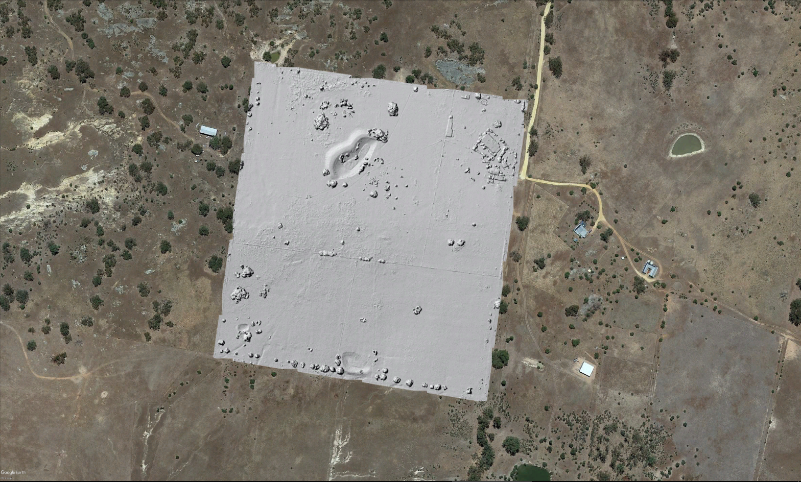
- 3D Model (.obj)
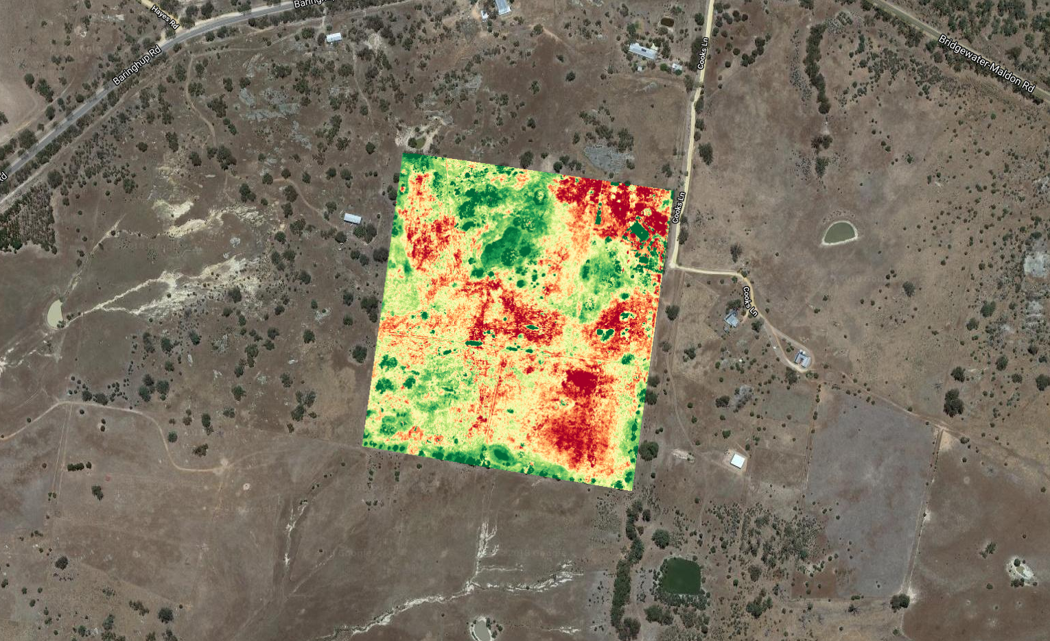
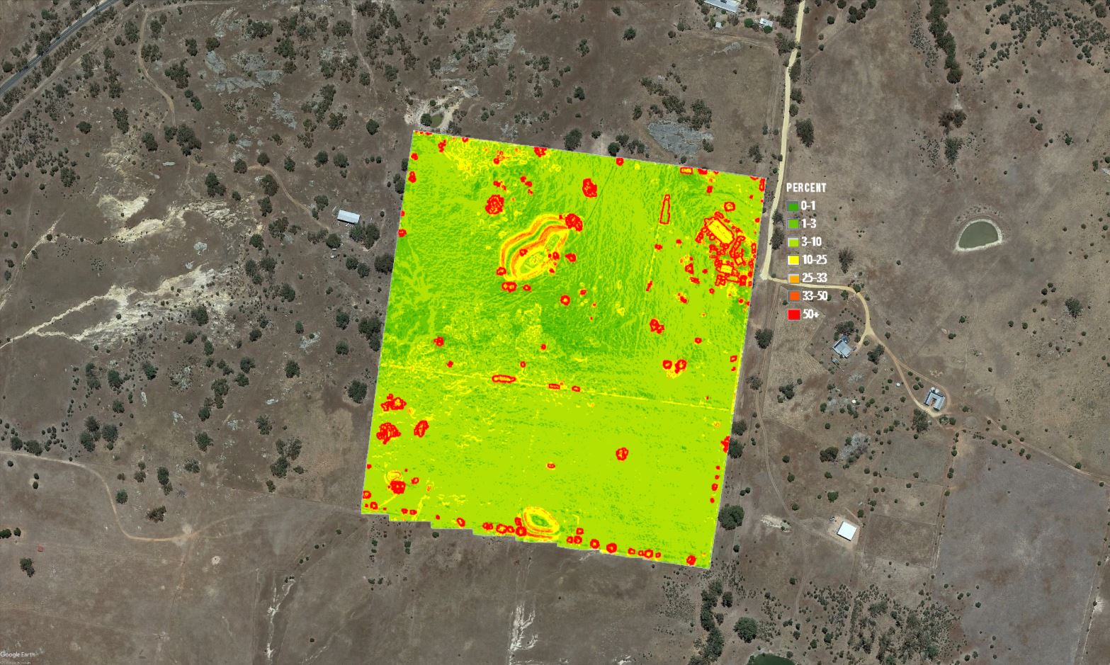
- Plant Health (.GEOTiff / .kmz)
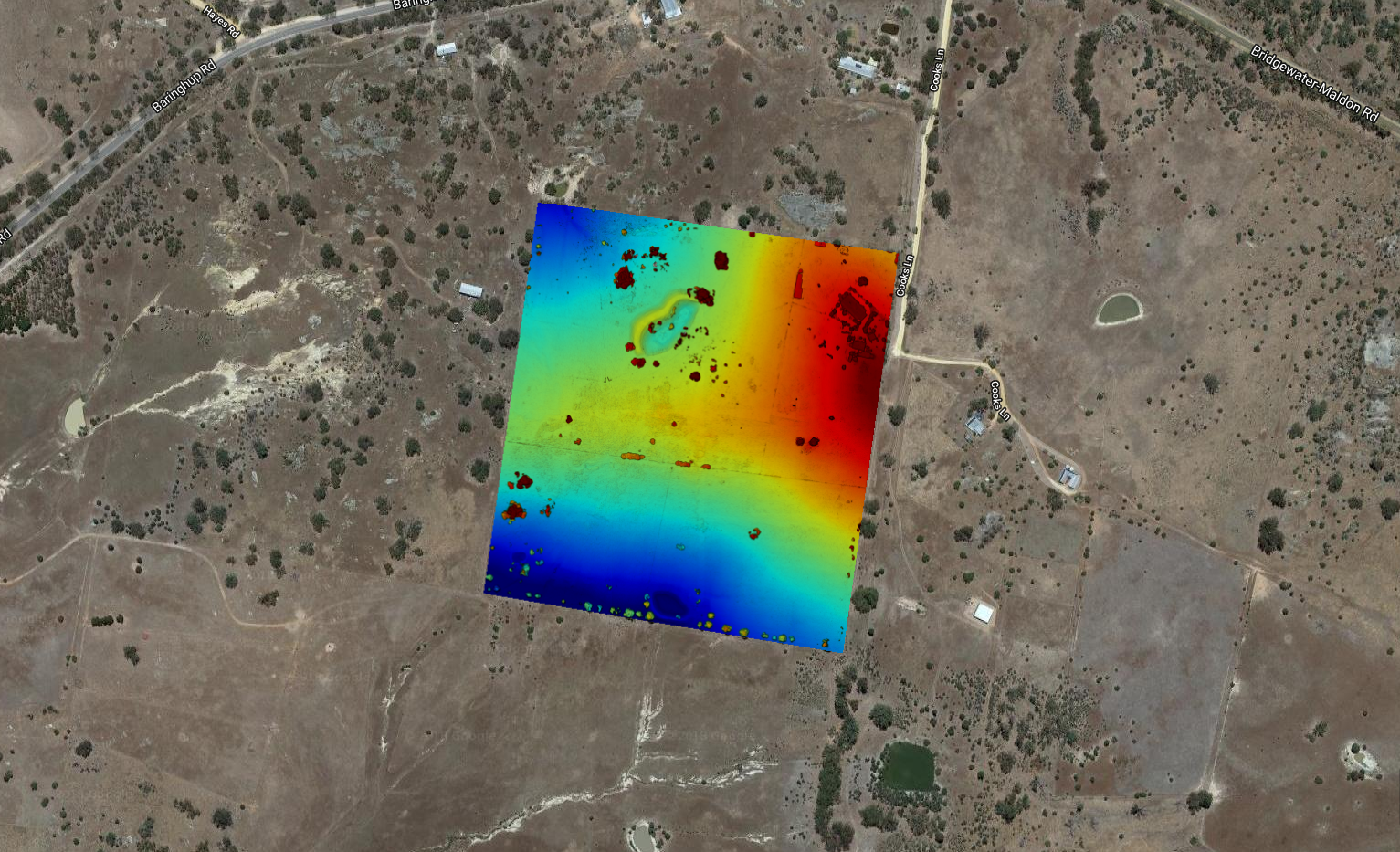
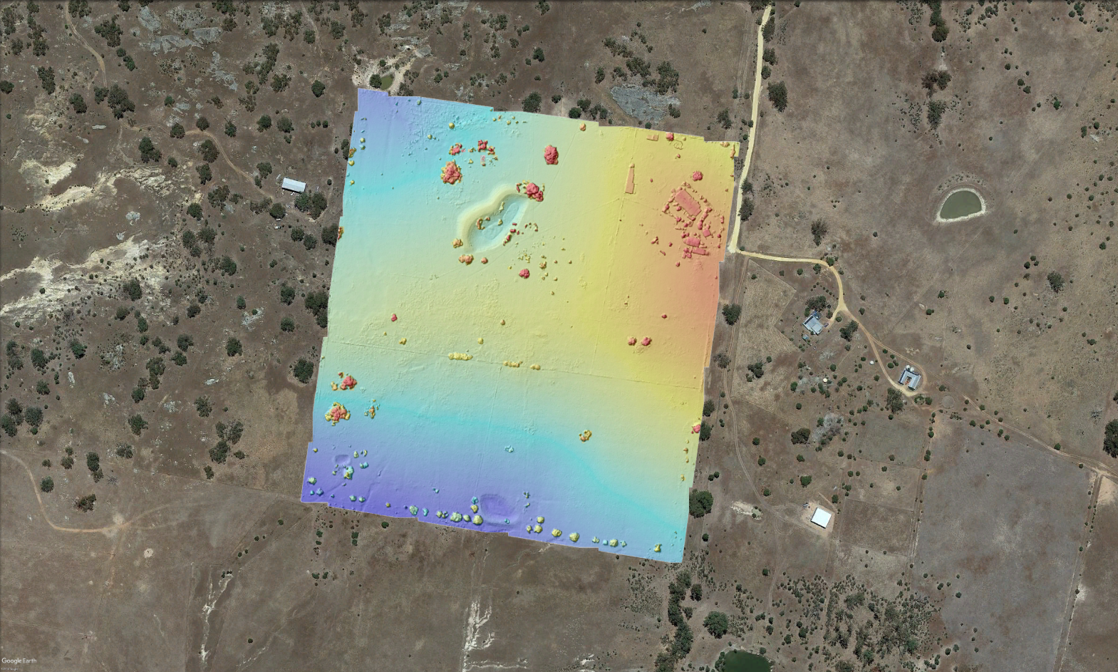
- Elevation (.GEOTiff / .kmz)
- Contours – 0.25 m, 0.5 m, 1m, 1.5 m (.kmz / .shp) – unoptimized, as received by Drone Deploy. They may contain some noise.
- Live Preview Link – This is a permanent link to the project. You or anyone you give the link to can use it to view the project 3D model and other outputs directly in the browser
PRECISION
USD $170 per flight (< 3000 images)
Our Precision services differ from the Standard by additional mapping outputs and a very high degree of accuracy that is achieved by the use of precision surveyed ground control points.
PROCESS
- Contact
Contact us about your project and send us in a .kmz file the boundary of the area subject to mapping. We will then write back to confirm we can take on your project. - Payment
You then pay the entirety of the fee for the service through this web page. - Flight Plan
We will then create an optimal and safe flight plan and send it to you. - GCPs & Fly
You then capture the necessary number of Ground Control Points. Afterwards, you then fly the UAV in accordance with our plan (optional). Alternatively, you can also choose to follow your own flight plan. - Data
You send us via Google Drive all of the imagery captured during the fly flyover as well as the GCP .csv file. - Processing
We will process the imagery and GCPs and create all of the mapping outputs for you and send them over via Google Drive. - Feedback
We will ask you to preview the outputs in case something needs to change. - Delivery
We will perform any necessary iterations and send over the final outputs.
OUTPUTS
- Orthophoto mosaic (.GEOTiff / .kmz)
- Digital Surface Model (.GEOTiff / .kmz)
- Digital Terrain Model (.GEOTiff / .kmz) – Under forest canopies, we’ll interpolate bare earth ground to as high a quality as photogrammetry technology currently allows for
- 3D Model (.obj)
- Plant Health (.GEOTiff / .kmz)
- Elevation (.GEOTiff / .kmz)
- Live Preview Link – This is a permanent link to the project. You or anyone you give the link to can use it to view the project 3D model and other outputs directly in the browser
- Contours – 0.25 m, 0.5 m, 1m, 1.5 m – optimized (.kmz / .shp)
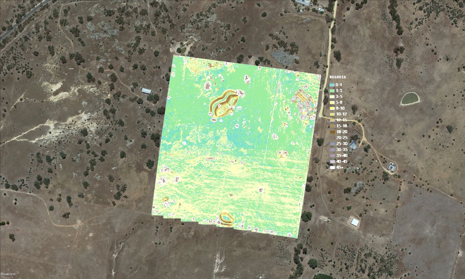
- Slope (.tiff / .kmz)
- Land use (.tiff / .kmz) – Where applicable
- Hillshade (.tiff / .kmz)
- Topographic Wetness Index (.tiff / .kmz) – Our algorithm combines Flow Direction, Watershed, Waterflow, and Normalized Difference Water Index
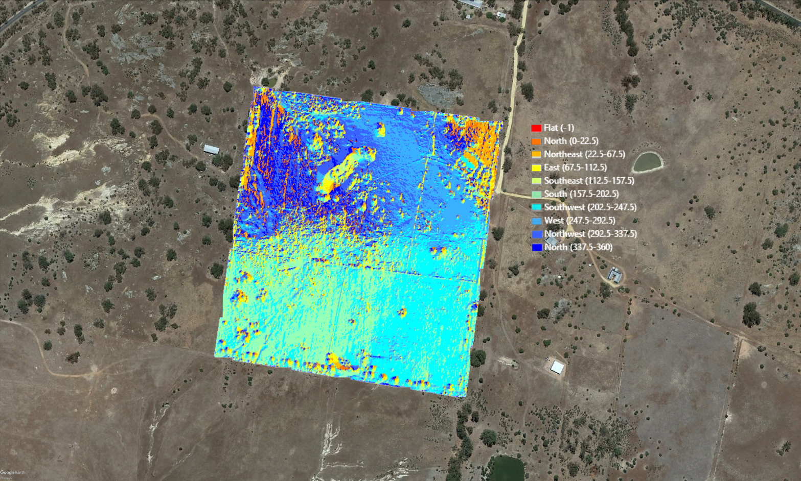
- Aspect (.tiff / .kmz)
FLY
AUD $1500 per day
If you want us to handle everything from flight planning, flying and precision surveying, through to processing and output, then this service is for you. Limited to Australia and New Zealand.
PROCESS
- Contact
Contact us about your project and send us in a .kmz file the boundary of the area subject to mapping. We will then write back to confirm we can take on your project. - Proposal
We will then create a proposal for you based on your needs and send it over. - Payment
If you agree with our proposal, we will then send you an invoice for the entirety of the service cost. - Travel to Site
We will travel to the site when weather conditions look to be favourable for mapping. - Fly & Survey
We will collect precision Ground Control Points and perform the flyover. - Processing
We will travel back to our HQ and carry out the processing of the captured data. - Feedback
We will then deliver the outputs to you for preview and ask for feedback. - Delivery
We will perform any necessary iterations and send the finalized outputs to you via Google Drive and/or email.
OUTPUTS
- Orthophoto mosaic (.GEOTiff / .kmz)
- Digital Surface Model (.GEOTiff / .kmz)
- Digital Terrain Model (.GEOTiff / .kmz) – Under forest canopies, we’ll interpolate bare earth ground to as high a quality as photogrammetry technology currently allows for
- 3D Model (.obj)
- Plant Health (.GEOTiff / .kmz)
- Elevation (.GEOTiff / .kmz)
- Live Preview Link – This is a permanent link to the project. You or anyone you give the link to can use it to view the project 3D model and other outputs directly in the browser
- Contours – 0.25 m, 0.5 m, 1m, 1.5 m – optimized (.kmz / .shp)
- Slope (.tiff / .kmz)
- Land use (.tiff / .kmz) – Where applicable
- Hillshade (.tiff / .kmz)
- Topographic Wetness Index (.tiff / .kmz) – Our algorithm combines Flow Direction, Watershed, Waterflow, and Normalized Difference Water Index
- Aspect (.tiff / .kmz)
CONSIDERATIONS
- You must use a Drone Deploy compatible UAV – e.g. DJI Mavic, Phantom, etc.
- You or other parties under your direction will fly the UAV over the site you want to be mapped. Whoever is operating the UAV must be proficient in flying a UAV and abide by any regulations that govern the use of UAVs in your area.
- We can generate the flight plan for you but you should always use your own discretion whilst on site, especially when it comes to setting up the flight altitude in order to avoid collision with any objects (e.g. trees, buildings, powerlines, etc.). Alternatively, you can create your own flight plan and just send us the images for processing.
- You must send your images to us via a Google Drive folder with editable permissions.
- Ground Control Points must be supplied in metric and using either the Web Mercator Projection (EPSG 3857) or WGS 84 (EPSG 4326) projections in a .csv file.
- The highest altitude a UAV can fly at in Australia is 120 m.
- Fly service — Travel and accommodation costs are not included in the price of the Fly service but are instead subject to quotation. The general flight maximum time per day is 5 hours, – between 1000 AM & 1500 PM. The time between and after flight time is spend plotting GCPs and processing flight data.
FREQUENTLY ASKED QUESTIONS
- Do I have to be a member of the Regrarians Workplace to work with you?
Yes, we are currently catering only to the needs of subscription members of the Regrarians Workplace. If you would like to become a member, please visit our subscription page. - Do subscribers receive a free mapping service?
Yes, all Planner subscribers receive 1 x Precision/Standard service for free as part of their subscription. - How long will it take?
Most of our analytics-related work takes no more than a couple of hours. Highly complex tasks, however, may take up to 1 business day or more. - When can you start?
Typically the same day, but it is best that you contact us as soon as possible because we are typically booked far in advance. - What data can you work with?
We can work with any type of data and format. Similarly, we can export or convert data to any format. - What data is required from me?
For our Standard and Precision services, you only have to send us a .kmz with an outline of the area of interest so that we can generate a flight plan for you. After you fly the UAV in accordance with our plan, you have to send us also the photos via Google Drive so that we can process them for you. For our Geomatics service the data you have to supply us with depends on what outputs you are interested in. - What maps can you produce?
Our service is not limited to the types of maps listed in the services table above. We can produce virtually any type of map, so long as we are supplied with the appropriate data. - Can I bundle multiple sites together?
Yes, provided that: (1) the sites are part of the same property and in close proximity to each other; (2) the total number of images does not exceed 3000; (3) GCPs (if any) for all sites can be used as part of the same processing. If any of these 3 conditions are not met, we will typically not allow for bundling. - Can you teach me to operate a UAV?
No. It is entirely your responsibility to know and abide by your local regulations and to understand how to safely operate a UAV. - Where can I find learning resources on UAV mapping?
We suggest visiting Drone Deploy‘s video, resources and support page for in-depth coverage of most of what you have to know to safely and successfully operate UAVs for mapping purposes. - What is the accuracy of your output?
In the case of the Standard service, the horizontal and vertical accuracy of the output depends entirely on your UAV’s internal global positioning system. Unless you are running a UAV equipped with a highly accurate positioning system (e.g. Phantom RTK, SenseFly, etc.), you can typically expect some 1-10 meters of deviation. You can greatly reduce the margin of error via the use of Ground Control Points, in which case you would have to contract our Precision service (see below). - What is the quality of your output?
The quality of the mapping output is directly tied to the quality of your drone hardware and the efficacy of your flight. If your photos are blurry, over or underexposed, discoloured, cropped out, etc. you can expect those defects to be reflected in the processed output. Please carefully inspect your photos prior to sending them to us. - What UAV do I need?
It really depends on what you have set out to accomplish and on your budget. If you are about to map a smaller site of say up to 500 Ha, then consumer UAVs like the DJI Phantom or Mavic Pro should suffice. But if you are intent on broad acre surveying, then we recommend that you look towards other, ideally fixed-wing, modular and longer flight solutions (e.g. Event 384). Whatever the case, your UAV must be compatible with Drone Deploy if you wish to use our service. Also consider that going beyond a certain craft weight ( > 2 kgs for Australia) may put you under a legal obligation to register as a pilot, which entails covering substantial costs and following special procedures. - If I have the Phantom 4 RTK is the Precision service obsolete for me?
In short, yes and no. Since the RTK module and TimeSync of the P4RTK embed the sub-centimetre accuracy directly into the image’s metadata, you no longer have to carry out a precision survey of Ground Control Points and therefore you don’t need to use our Precision Service to get the accuracy. Instead, if you use the Standard Service you will achieve the same level of accuracy. However, by using the Standard Service you will not get the benefit of the additional mapping outputs such as optimized and cleaned up contours, slope, hillshade, aspect, etc. that are included in our Precision Service by default. If you need those, you will have to purchase them separately. - Why is my Orthomosaic output not loading/displaying in Google Earth? Why is Google Earth crashing?
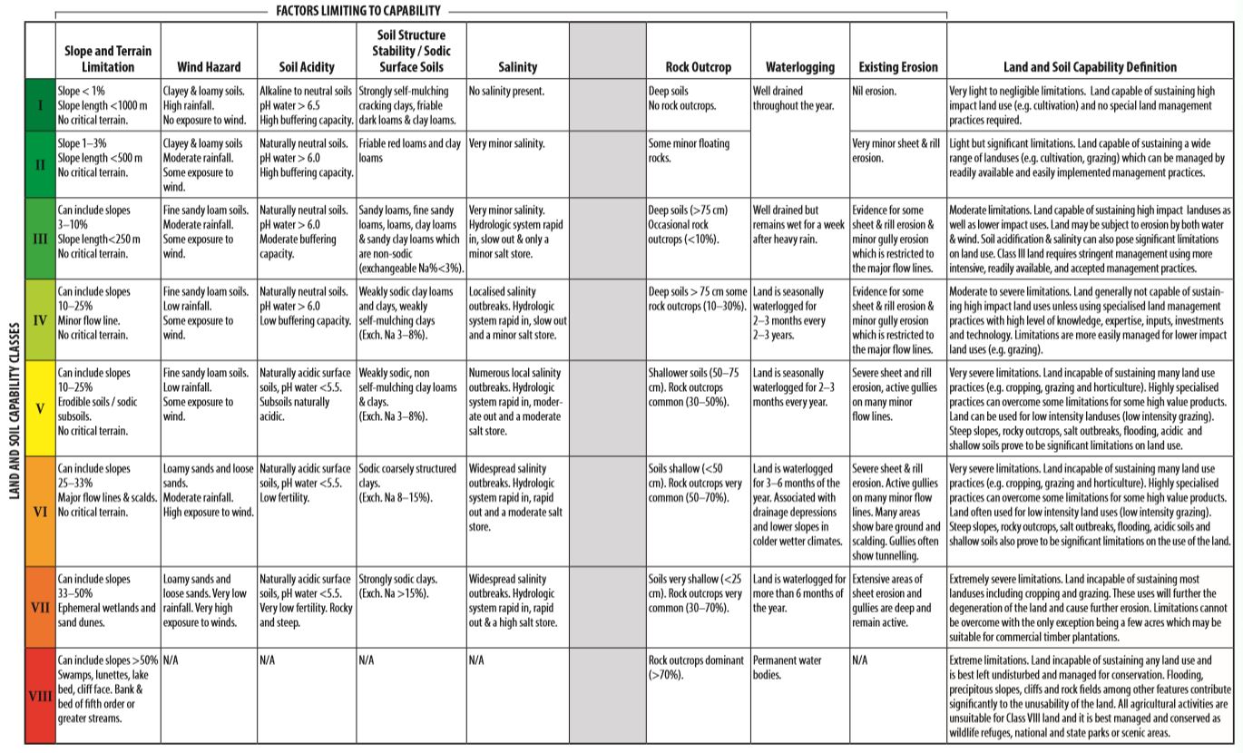
This is not an issue with our output, but with Google Earth. Unfortunately, Google Earth can only display images up to a certain resolution. From our testing, that limit comes up to around ~10 000 px wide. Most of our Orthomosaics are over 35000 px wide at maximum resolution. This is the main reason why Google Earth may not be able to display your output. Sadly, there is no way around this other than to create a down-sampled version of your output for use in Google Earth. For this reason, in addition to providing you with the maximum resolution output, we also create for you a 10 cm/px and 20 cm/px versions for use in Google Earth. - Of what use are the optimized contours?
Optimizing your contours is very important if you are intending to use them for tasks such as those pertaining to technical design, – e.g. dam, road, channel or earthwork design. It is important because non-optimized contours can be heavy and difficult to work with due to the presence of noise and too many vertices. Furthermore, contours used for technical design are typically smoothed in order to reduce the likelihood of software errors during triangulation calculations. Some sites with high grasses may also generate an extreme amount of contours to the point that they become unusable just due to sheer visual noise, in which case optimization is also useful. We also recommend slightly smoothing out contours prior to using them for planning in order to avoid the naturally occurring jaggedness which may cause erratic behaviour in design and engineering software. - Can you look for mapping data for me?
No. Regardless of which service package you purchase, we only process mapping data that you provide us with. We cannot spend the time looking for the data ourselves.
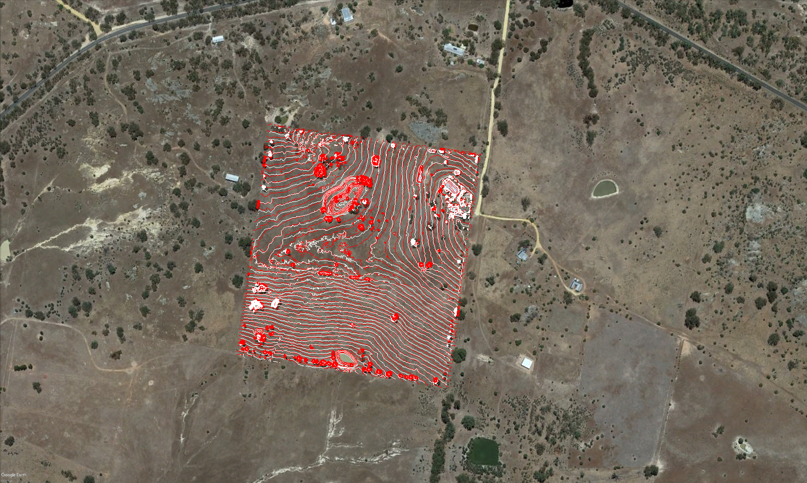
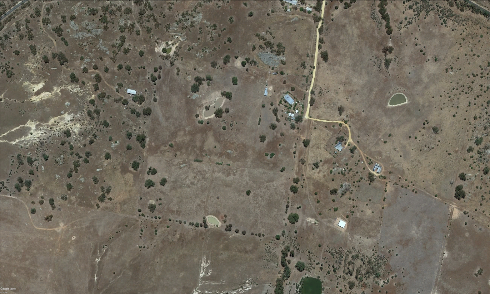
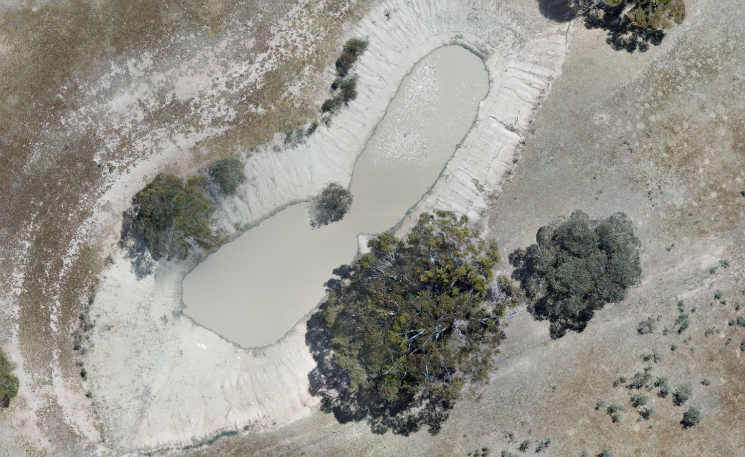
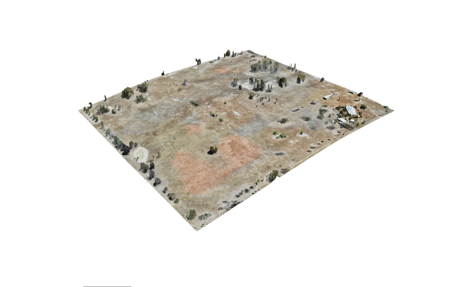
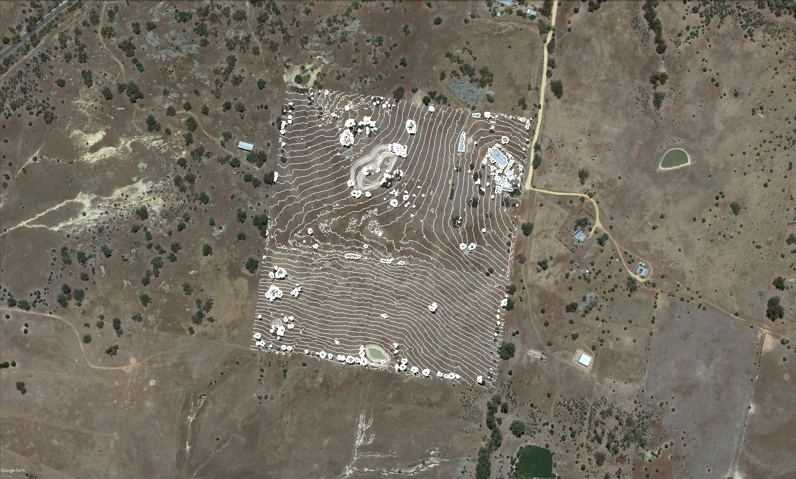
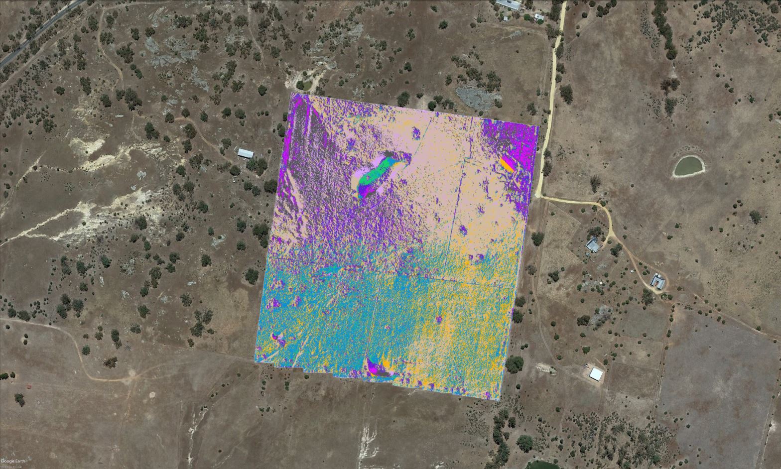
EXAMPLE OUTPUT
- Project Name: Tarrengower
- Location: Australia, Victoria
- Date: November 26, 2018
- RTK Ground Control Points: Included
- Area: 16 Hectares
- Images: 1990
- Flight Altitude: 30 Meters
- Side Overlap: 65%
- Orthophoto Resolution: 1.68 cm per pixel
STANDARD SERVICE
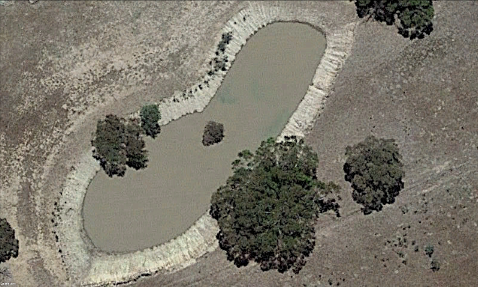
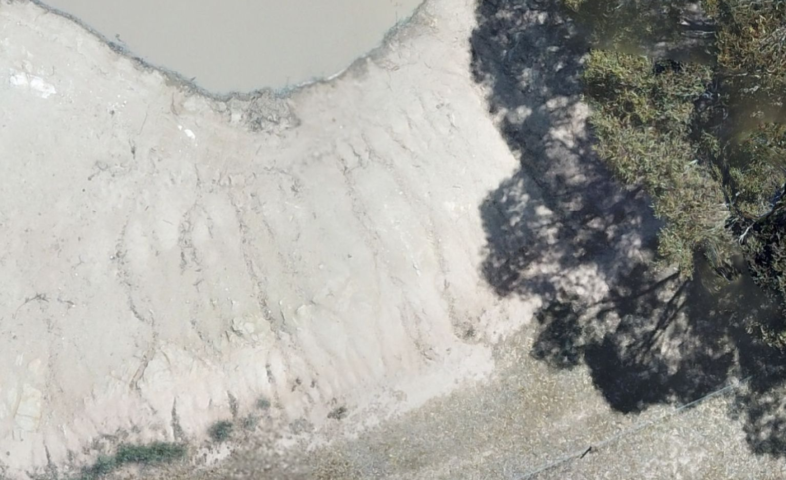
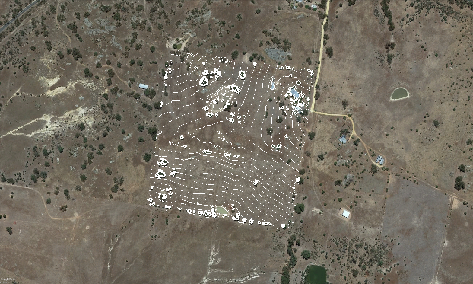
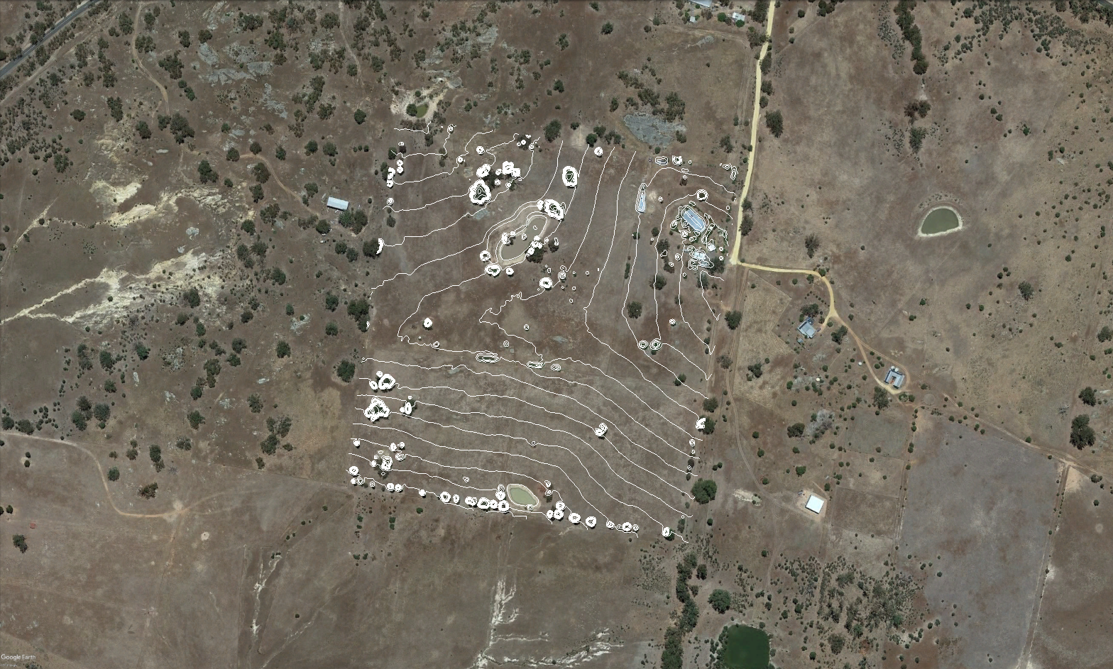
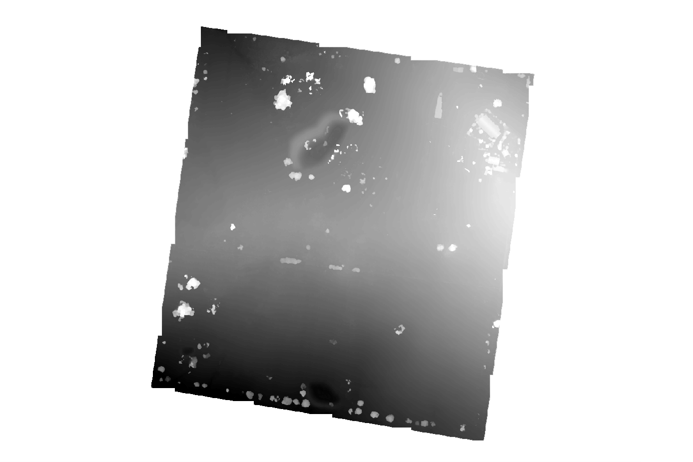
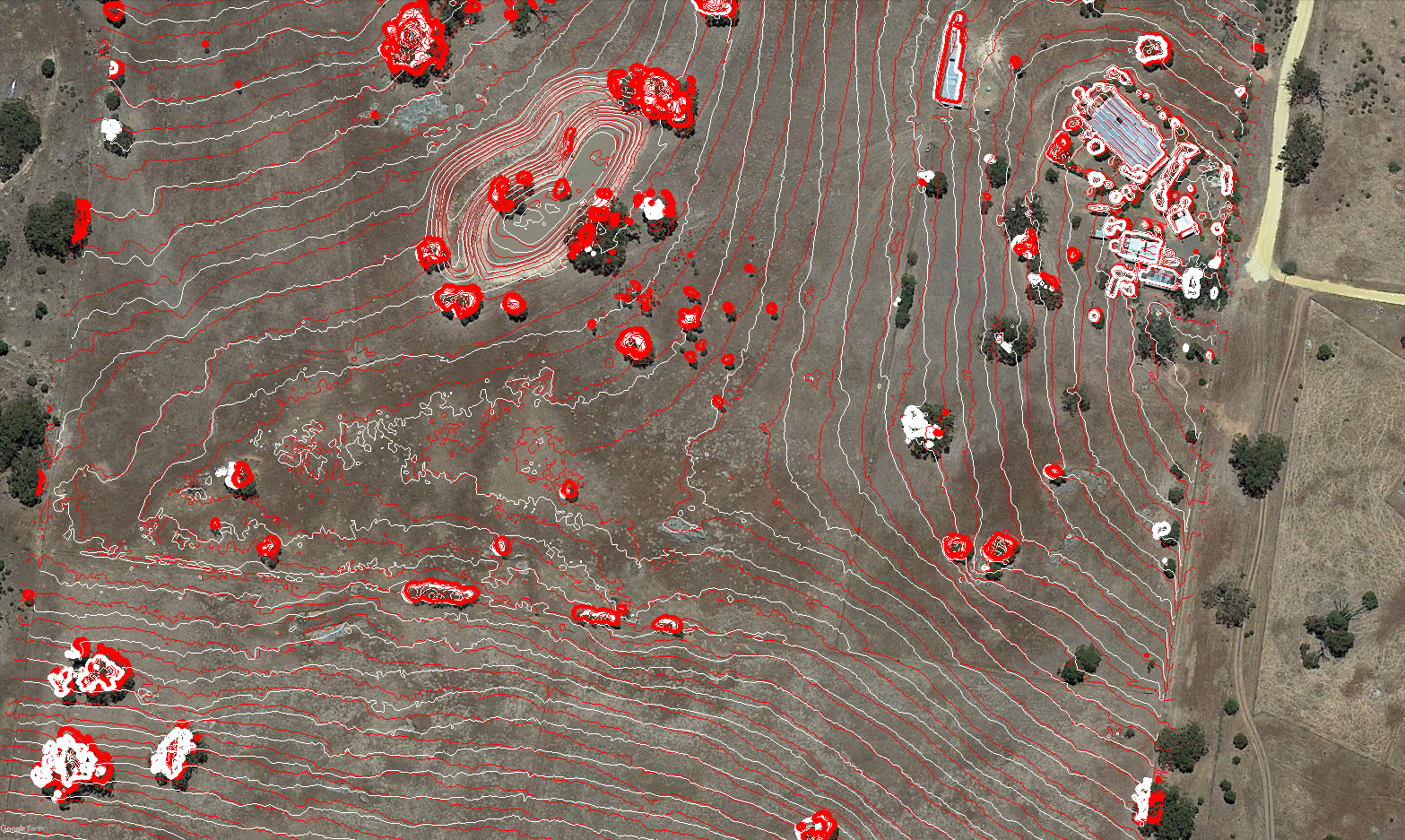
PRECISION / FLY SERVICE
Our Precision / Fly services include all of the outputs from the Standard service shown above, as well as the following additional outputs that are shown below.
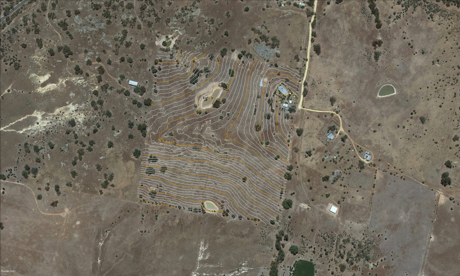
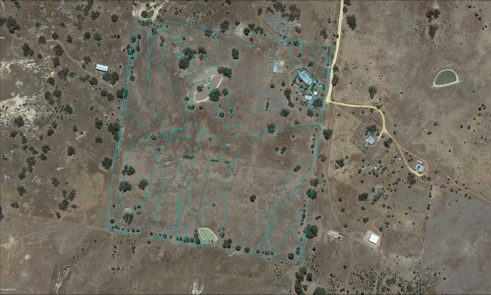
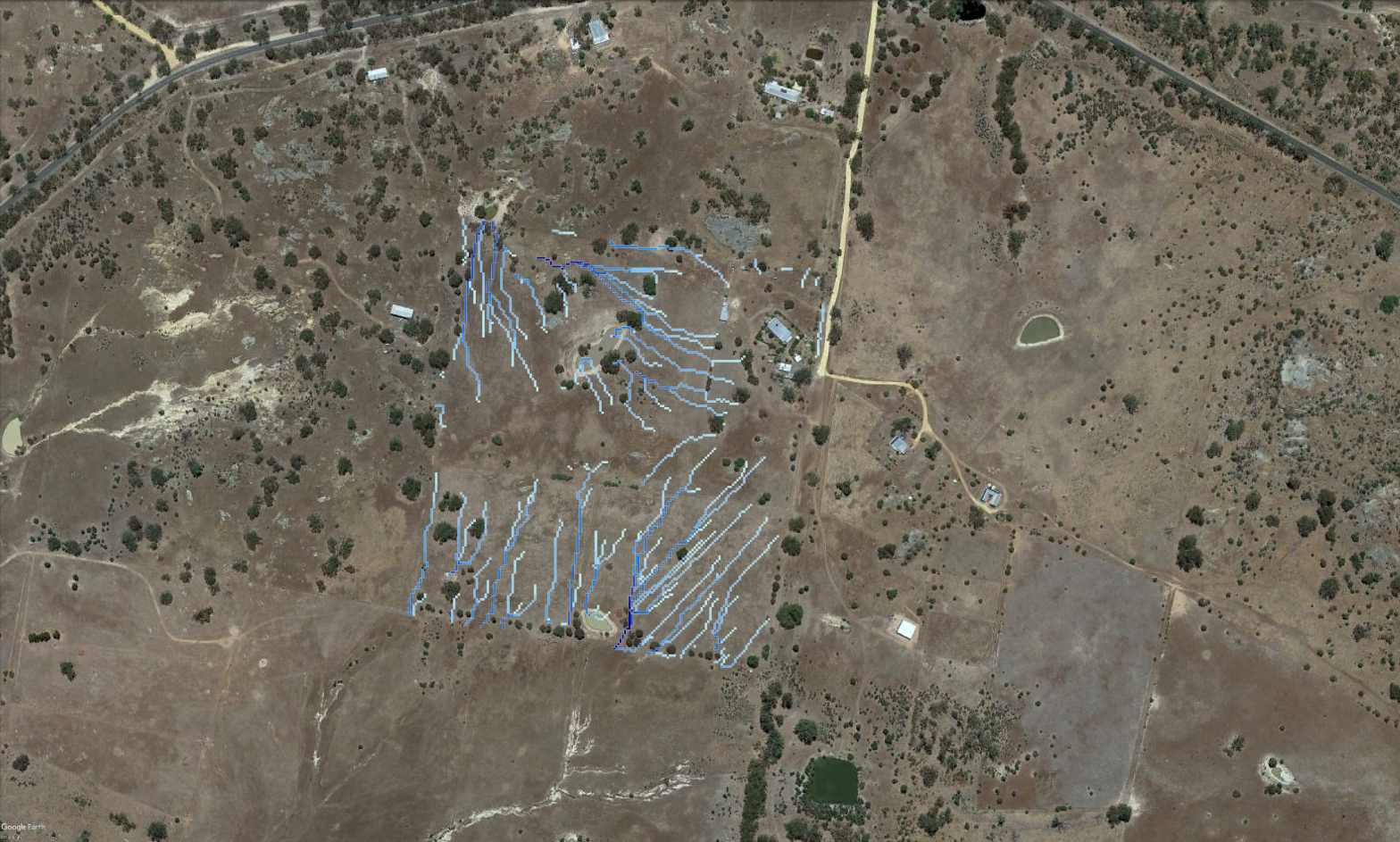
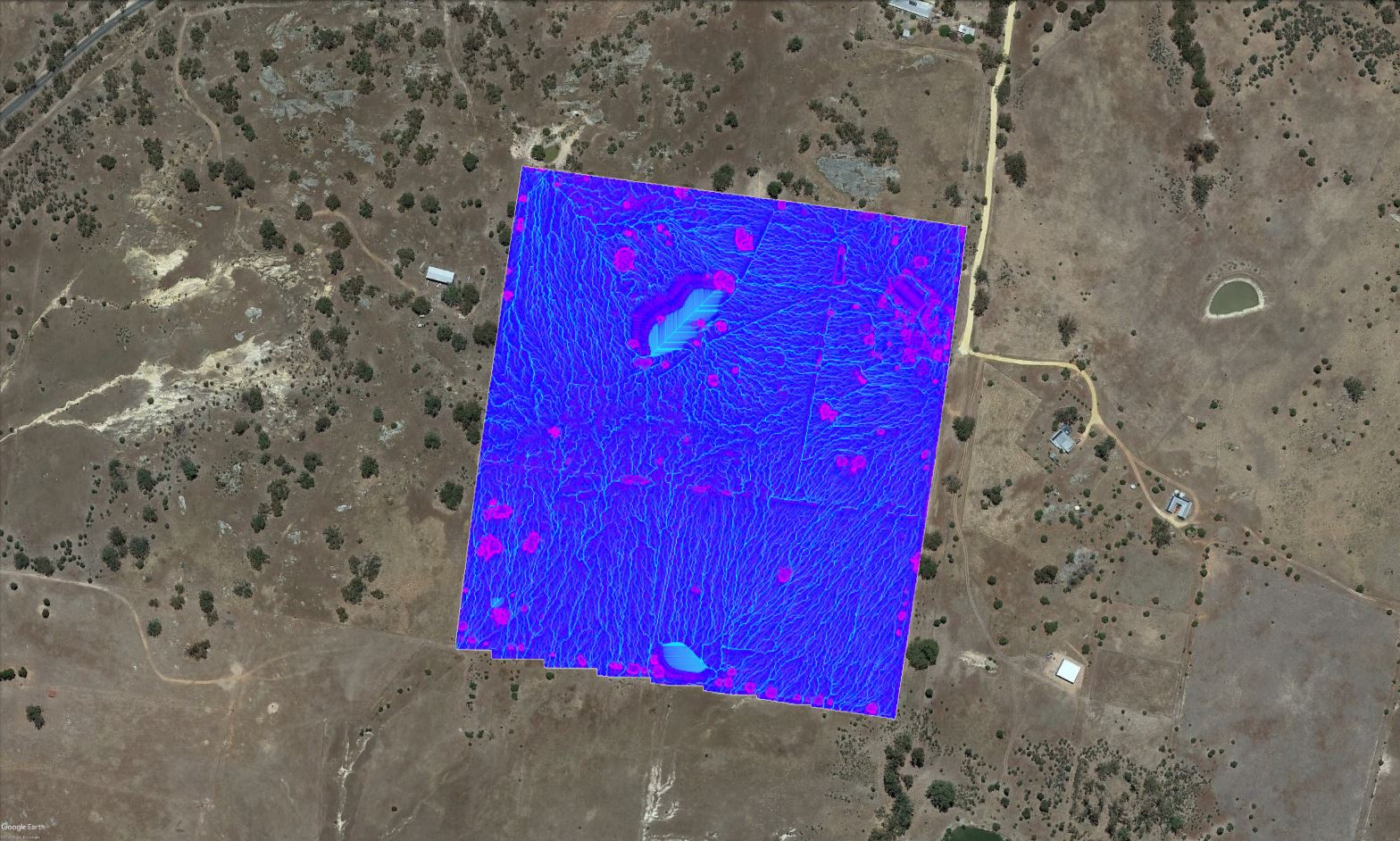
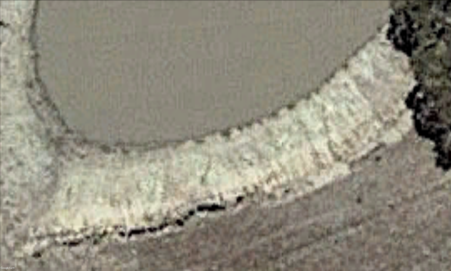
RTK GCP-BASED CONTOURS vs STANDARD CONTOURS